It looked like it would be a nice day. Things were a little soggy from the rain last night, but the sun was shining now. Packed up a slightly wet tent, and a soaked and muddy footprint. Had a gradual uphill climb to Lone Mtn. Passed 4 of the older people who woke me. Cruised on a nice section of trail leading up to Spaulding Mtn Lean-to. Had an early lunch and dried out my tent in the sun. I took a look at my guidebook and realized that in 1.7 miles, I would hit the 200 miles remaining mark. I immediately got a feeling of excitement! When I go to Spaulding Mtn, I took the blue blaze trail to the top, hoping for a good view. The summit had a lot of trees, which prevented getting a good view. Carried on and made my way to Sugarloaf Mtn which is also a ski resort.
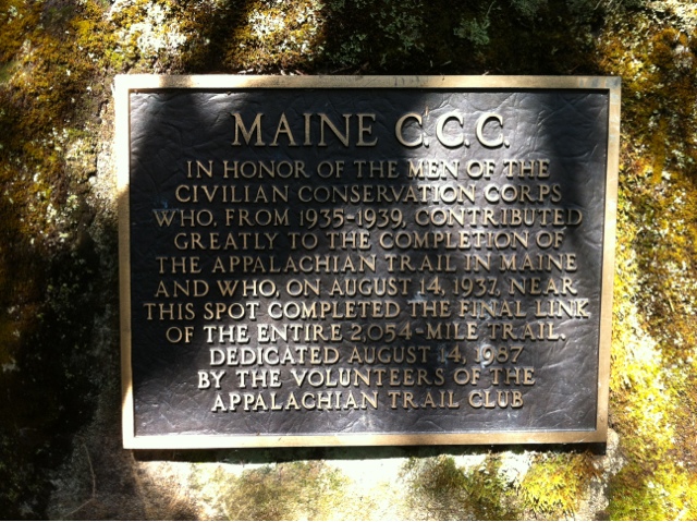
Along the way to Sugarloaf, I reached the 200 miles til Katahdin point. No sign to acknowledge this, but shortly after, there was a sign on a boulder stating that the area I was in was where the final link of the AT was completed back on August 14, 1937. There was also a temporary sign stating that the AT is celebrating its 75 year anniversary tomorrow. Back in 1937, the trail was 2,054 miles long. Today, after trail reroutes and modifications, it is at its longest length, at 2,184 miles. I signed the log book and took a lapel pin they had for thru hikers there.
As I got to the side trail to Sugarloaf peak, I decided not to go. A sobo said it wasn't really worth the additional mile. I talked to some section hikers for a bit, then headed on. If I wanted to get to Stratton tonight, I had 9.9 miles and it was about 2:30pm. I started trucking on and went down the steep grade of Sugarloaf, took a break down by the river, then it was on to tackle South and North Crocker Mtns. Some section hikers at the base of South told me it was really steep and tough. I pushed going up and kept a strong, steady pace, trying not to stop my drive. I made it to the summit, sweat pouring and heart pounding, but without stopping.
There was a downhill into a saddle, and back up to get to North Crocker. When I got up to the top there was a small summit clearing. I sat and took a short break, then began the 5 mile hike down to Hwy 16. The 5 miles seemed to go on forever, but eventually I made it to the road around 6:45pm. I had done the Crockers and not seen one person. I had them all to myself.
I got a ride into Stratton and grabbed a bite to eat. In this small town, all but a convenience store and a gas station stay open past 8pm. After my Wolf Burger (a huge burger with a sausage patty on top of the beef patty) from The White Wolf, I walked around town and low and behold, came across a little league field. As I was already familiar with using a dugout as a shelter, I did the same here. This one was nicer and larger. (I sound like a connoisseur, right? What's your specialty? "Oh, mine? Baseball field dugouts."). Anyway, I set up and went to bed after a challenging 21.5 mile day.
188 miles left to go.


No comments:
Post a Comment